Lake Huron: St Ignace, Michigan, to Detroit, Michigan

I must admit to some trepidation as I planned this trip. Although my daughter Kathi and I had done long haul traveling together, and she accompanied me on a short sortie to the Apostle Islands, this would be a ten day lighthouse focused trip on the backside of Lake Huron all the way to Detroit where Taylor, Kathi’s son and my grandson lived. My lighthouse roadtrips were much like a mission, time imperative, which foreclosed on leisurely sightseeing. How would Kathi like serving as copilot and relief driver on such an undertaking?
There were other concerns not the least of which were air quality alerts. These were now common in Minnesota with smoke coming from active fires in Ontario—the very place we were going. We packed some N95s, but they wouldn’t help with the extreme heat. Both caused by global warming which the conservatives had chosen to ignore.
Covid, of course, was still out there but now termed an ordinary illness by the CDC. Still an issue for those whose prime is past. The length of the trip—three weeks is a long time for me to be away from family and friends. But if I make this list of detractors any longer, I’ll end up staying home.
I’m encouraged by John Wesley Powel’s celebrated quotation from his expedition down the Colorado River in 1869.
We have an unknown distance yet to run, an unknown river to explore. What falls there are, we know not; what rocks beset the channel, we know not; what walls rise over the river, we know not. Ah, well! We may conjecture many things.
Unlike Powel I have both my arms.
I suspect I wouldn’t be making these long sketching trips if my wife Sheryl were still alive—to a large extent they’ve just helped fill the emptiness.
***
DAY 1 I’d bribed Kathi with the promise of dinner at the Grand Hotel on Mackinac Island in Lake Huron, and that was our objective as we left my house on a cool cloud free morning, taking a diagonal across Wisconsin to Iron Mountain, Michigan. Daisies, Sheryl’s favorite, were blooming all along the road.
DAY 2 Mackinac Island didn’t disappoint us. Good view of Round Island Lighthouse as we came in on the ferry. We rented a carriage, which came with a horse, Timmy, a Belgian Cross. He knew the route well but had to be steered clear of the shortcuts back to the stable. At the hotel a six course dinner served up by waiters in fancy atire. Kathi had the best ever calamari, lentil and stone fruit soup, and fennel crusted pork loin. I had schnitzel. It was fun dressing up and pretending to be rich.

Round Island Lighthouse directs west bound ship traffic to the north channel between Mackinac Island and Round Island. The island is not round, it may have been named after the lighthouse builder, Frank Rounds, who completed the project in 1895. The lighthouse was deactivated in 1955 and no longer shines, but Round Island Lighthouse Preservation Society has been taking care of it.
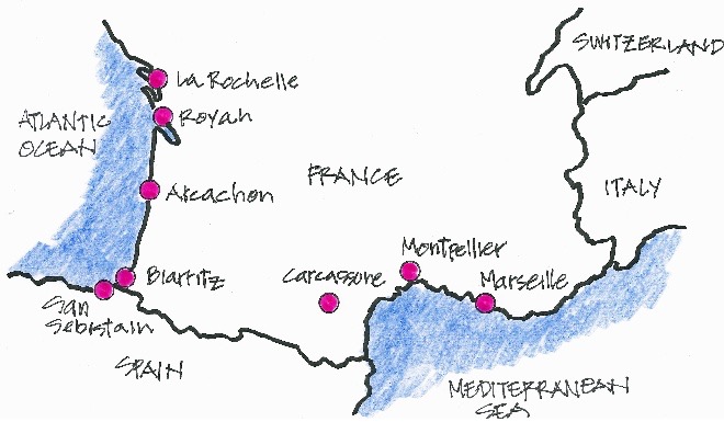
DAY 3 Next morning we were back on the ferry and then a quick drive to sketch the Wawatam Lighthouse in St Ignace, Michigan, at the end of a breakwater extending from a city park. Kathi walked all the way to the end while I stopped midway to sketch.

Wawatam Lighthouse may well be the newest lighthouse in the US. It was originally built in 1998 by the Michigan Department of Transportation as a tourist attraction near Monroe, at the southeast corner of the state of Michigan. In 2004 MDOT decided to tear it down, but the City of St Ignace offered to take it off their hands and move it to their city. The steel structure was taken apart, moved to St Ignace where the Coast Guard keeps a functioning beacon, and the city maintains the lighthouse.
Then off to Sault Ste Marie, Michigan, so I could sketch the relocated Frying Pan Island Lighthouse. We toured the Louis W Hill now known as the Valley Camp, a 550 foot ore boat with up-front pilot house.

Frying Pan Island Lighthouse used to sit on Frying Pan Island so named by Captain William Thorn, allegedly the first person to sail up the St Marys River into Lake Superior. He’d found a frying pan on the island. The 1882 riveted steel plate lighthouse was only 18 feet tall. Two years later a lighthouse was built to the north on Pipe Island—probably named thus because someone found a pipe there—and the two lights became a range for DeTour Passage into Lake Huron. The lighthouse was discontinued in 1937 and in 1988 the Coast Guard relocated it to embellish their headquarters in Sault Ste Marie.
The resort on Manitoulin Island where we’d hoped to stay was suddenly booked for a wedding. They suggested a Bed and Breakfast, but no dice. So the plan became drive on to Sudbury, Ontario, spend the night, drive back to Manitoulin in the morning, and back to Sudbury that night.
While Kathi drove, I used my iPhone to locate Richards Landing Lighthouse on St Joseph Island. Google Maps got us lost, but we eventually got across St Joseph Channel and onto the island. As I sat sketching a guy came up to me and asked, “Is that your chair?”
“Yes, it is.”
“My brother just loaned his to someone and I thought it might be you. I own the company that makes these chairs.”
“Wow! I love this chair. It’s a Kermit chair—made in Kentucky. I just bought it.”
“Yes, Kermit retired a while back, and I bought the company. I’ve now got a place up here.”
Small world.

The original Richards Landing Lighthouse was placed on the roof of a warehouse. In 1940 a light on a post replaced it. With contributed funds a facsimile lighthouse was built at the public marina in 2009. It displays a green flash every five seconds. This was the first of many lighthouses painted white with lipstick red trim.
We drove back across the bridge and sighted Wilson Channel Rear Range Lighthouse up in the trees. While Kathi drove on to Sudbury, I checked our itinerary only to find that some of the distances on my spreadsheet itinerary were in kilometers not miles, cutting us a little slack.
DAY 4 In the morning we crossed the swing bridge to the Little Current Lighthouse on Manitoulin Island, the largest freshwater island in the world—100 miles east to west and 50 miles north to south—with numerous bays and lakes.

Little Current Lighthouse is a boxy 2012 replica of the original 1867 range light which was discontinued in 1937. The swing bridge, which permits only one way traffic, is in the background.
While I sketched, Kathi went into the town of Little Current, Ontario, and discovered the Boyle Marina Lighthouse—which can’t be found on lighthousefriends.com—as well as a bunch of cute little shops. I bought a map of Manitoulin Island.

Boyle Marina Lighthouse is a recent addition to the Boyle Marina offices.
We asked Patrick Boyle, the marina owner, about his lighthouse. Turns he just built his offices shaped like the Strawberry Island Lighthouse. His great grandfather, William Boyle, had been keeper at Great Duck Island Lighthouse from 1919 to 1931.
After chatting we drove back up the hill and turned south on ON-6 to Manitowang Lighthouse which sits across the street from a large lawn belonging to St Paul Church. Not much going on in this sleepy little town. Kathi made us a picnic luncheon.

The 1885 Manitowang Lighthouse is a typical Ontario lighthouse—pyramidal style, white field with red trim, square balcony. The light was changed from fixed white to fixed green in 1951 and automated in 1960. The Coast Guard renovated in 1995.
Next stop was South Baymouth at the entrance to South Bay. Lots of folks enjoying its sandy beach on this warm sunny day. We could have taken the ferry from here to Tobermory on the Bruce Peninsula, but we’d have missed a lot of lighthouses. I sketched the South Baymouth Outer Lighthouse from the boardwalk while Kathi explored this touristy town.

The South Baymouth Outer Lighthouse was built in 1898. The 28 foot tall lighthouse displays a fixed green light and a vertical red daymark like the one on the Cheboygan River Front Range Lighthouse—maybe purchased from the same seller.
The South Baymouth Inner Lighthouse was ensconced in foliage and difficult to find. I sketched from the edge of the parking area used by the beach visitors.

South Baymouth Inner Lighthouse bears the same day mark as the outer. It’s well hidden among the back yards of various houses.
We wended our way west to Providence Bay where I finally gave up searching for the lighthouse—no divine providence for me. Kathi escaped the heat in a coffee shop and got on her laptop.
We decided Gore Bay and Janet Head Lighthouse should be our next objective. Lieutenant Wolsey Bayfield surveyed Lake Huron in the early 1800s and named places after his children—in this case his daughter Janet.

The second oldest still standing on the island, Janet Head Lighthouse was built in 1879. It tells a story of disaster. In April 1885 the wife and eldest son of the first keeper Robert Boyter set out across the frozen lake to the north shore of Lake Huron with a yoke of oxen. Deep snow on the lake delayed their crossing. Boyter’s wife died of exposure and his son was crippled by frostbite.
By the time I finished sketching, and Kathi finished skipping stones, it was dinnertime. Purvis Fish and Chips was successor to Gore Bay Fisheries, which was established in 1882. We ordered, of course, fish and chips. Then a quick stop at female owned Split Rail Brewery to pick up some interesting beer for Taylor, and it was back to Sudbury.
DAY 5 Rain overnight and clouds lingering in the morning. After breakfasting at MacDonalds—no cinnamon rolls at this Holiday Inn—we were off to the races. Drove all the way to the Canadian Coast Guard Station at Parry Sound. On the way we listened to The Lighthouse Keeper by Alan Baker—a truly terrible novel.
In Parry Sound, atop the guard station, we found the lantern room from Cape Robert Lighthouse,which had been on Manitoulin Island. Rain was pouring down, and with wipers whipping back and forth, I sat in the car and sketched.

This is not a lighthouse, it’s the lantern room from Cape Robert Lighthouse which has been incorporated into the guard shack at the Coast Guard Station in Parry Sound. The Cape Robert Lighthouse was demolished sometime in the early 1970s and replaced with a steel frame structure.
Just as I finished this sketch the rain collapsed to mist, and the sun appeared. On to Victoria, Ontario, which straddles Sturgeon Bay and Hog Bay. Victoria Harbour Rear Range Lighthouse is up top a hill across the street from a row of houses. The sign read ‘Do Not Climb,’ so I didn’t.

Victoria Harbour Rear Range Lighthouse was built by the Department of Marine in 1910 along with the front range light. The lights were electrified in 1951. A steel framed tower replaced the front range light in 1960, and both were decommissioned in the 1990s. The Township Heritage Committee took over ownership of the rear range light in 2004 and renovated it.
While I sketched Kathi scoped out the town and found a good place for lunch: the Village Mercantile, just down the street. There were several customers ahead of us and a 45 minute wait, so we settled for icecream cones and drove on to Wasaga Beach, Ontario—the longest freshwater beach in the world—and Nancy Island Lighthouse. A light rain was falling, but Kathi’s phone showed the storm nearly past.
I took my sketching gear, grabbed an umbrella, paid the admission fee to the Nancy Island Historic Site, and walked across the bridge to the island.
As I stood looking at the salvaged bateau display, the rain came back with gale force. Branches were flying about along with garbage cans and other debris. I was protected—or so I thought—by an angled wall framing the display. But when the wind shifted, I was soaked to the skin.
Meanwhile Kathi checked out the resort town and suddenly saw nearly nude beachers racing to their cars and beach balls and umbrellas flying across the flash-flooded road. She turned around while her phone blared a tornado warning and was waiting for me in the car. We made a bee line for Collingwood, Ontario, and the Holiday Inn where we had reservations. After a hot shower and dry clothes, we went back to the island and I sketched the lighthouse.

Nancy Island Lighthouse is a replica built on an island at the Nancy Island Historic Site. The schooner Nancy, the lighthouse’s namesake, was launched in 1789 as a merchant vessel to transport furs. She was requisitioned by the British at the outbreak of the War of 1812. Two years later she was attacked by three American ships, burned to the waterline, and sank, only to be rediscovered and raised to become the focus of the NIHS.
Once again Kathi found a great dining venue at the Tremont Café. We shared pinzimonio salad, sweet potato gnocchi, and chocolate & cherry desert.
DAY 6 We took a drive through downtown Collingwood, a delightful place. Being it was Sunday, there wasn’t a soul around. On our way north we stopped at Sunset Point Park so Kathi could walk the beach. I sketched a fake lighthouse.

This imitation lighthouse in Collingwood, Ontario, comes complete with a waterslide.
At Meaford, Ontario, there had been a rear range light supported by a steel tower mounted on top of the Meaford pumphouse, but not anymore. As more rain loomed, I sketched the breakwater light.

Meaford Breakwater Light.
Then we turned the corner and headed up the Bruce Peninsula to Cape Crocker where we fixed lunch out of the refrigerator in the trunk, and I sketched the Cape Crocker Lighthouse, a departure from the ubiquitous white and red pyramidal lighthouses.

The reinforced concrete octagonal Cape Crocker Lighthouse was lit in 1909, the first electric light in Canada. It replaced the original 1902 combined lighthouse and fog signal building which was razed in 1975 along with the keeper’s quarters. The light stands proud and tall and alone.
On we went to Cabot Head, but a gate blocked our way—no sketching here. Next stop was Tobermory Lighthouse, affectionately called Big Tub after Big Tub Bay. Big crowd at Big Tub, picnicking and swimming in the cold water. I just ignored them, and they ignored me

The 1885 Tobermory Lighthouse sits on an outcropping of Canadian Shield in Bruce Peninsula National Park. It marks the entrance to Big Tub Harbour which is a shelter in case of storms. Abraham Davis kept the light for ten years until he ventured out in a skiff to help a wrecked ship. He did not return. His widow Flora was highly recommended for keeper, but in a remarkable show of misogyny she was turned down, and Henry Davis was appointed instead. Davis was dismissed in 1901 for failure to attend the light.
While I was sketching, Kathi explored this bustling touristy town of Tobermory. She needed a break from Holiday Inns and booked us into the Red Bay Lodge, which was a delightful change of pace—woodsy, secluded beach, live music, fire pit, and sunset over the bay. We shared fish and chips and blueberry cheesecake washed down with local IPAs.
DAY 7 After an enormous English breakfast, we drove down to Southampton, Ontario, and the Saugeen River Rear Range Lighthouse.

The 1900 Saugeen River Rear Range Lighthouse is a typical Ontario style lighthouse. In 1989 the Coast Guard planned to strip off the exterior shingles and replace them with aluminum siding. The townspeople rose up in protest and held a three day round-the-clock vigil to protect the original siding. The Coast Guard gave up.
I set up my Kermit Chair near the street and sketched while a couple guys with pickup trucks loaded up furniture from the house across the street. Hope they weren’t thieves. Kathi came back from a marina photo spree, and we high tailed it down to McNab Lighthouse between Southampton and Port Elgin. It sits in someone’s backyard. I tried to be unobtrusive.

In 1877, range lighthouses were erected to mark the Southampton harbour entrance. In 1901, the rear light was relocated from the north point of Horseshoe Bay to the south point, known as McNab Point, hence the name McNab Lighthouse. The front light was deactivated in the late 1950s, but McNab remained in service. In 1988 the Coast Guard sided the lighthouse with aluminum siding which trapped moisture and led to the decay of the original shingles. In 2008 the Marine Heritage Society removed the siding and the rotted shingles and replaced them. The light was discontinued in 1989.
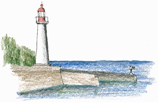
A half hour’s drive down the coast brought us to Kincardine and the Kincardine Lighthouse just across the Penetangore River from the marina. While I was sketching a charter boatload of fishermen disembarked, all smiles and happiness and beery. They loved my sketch.

Another relief from the cookie cutter lighthouses, the 1881 Kincardine Lighthouse sits proudly atop the two story keepers quarters. The Native American name for Kincardine was Penetangore, the river with the sand on one side. It was soon changed to Kincardine to honor the Scottish Governor General of Canada, James Bruce, twelfth earl of Kincardine. In the 1800s the two industries in town were fishing and salt extraction—a Paleozoic sea once covered this area. Breakwaters and lighthouses were necessary.
But there’s even more to the story. In 1856 immigrant Donald Sinclair and his family boarded a ship leaving Port Goderich for Kincardine. Off Point Clark a storm arose and as night fell visibility ground to zero. Sinclair broke out his bagpipe and began a lament. A piper in Kincardine joined in and the ship captain followed the sound into the harbour. Sinclair often went to the harbor and piped down the sun to honor the phantom piper.
The Point Clark Lighthouse sits at the end of Lighthouse Road in the busy Point Clark Beach Park. After looking through the museum, Kathi and I took the lighthouse tour. The docent walked with us. She said on a busy day she’d make 14 or 15 round trips to the top. No gym membership for her.
I was surprised that the stairs were made of wood—ships ladders from landing to landing—unlike most other lighthouses I’d seen which had cast iron spiral stairs.

Point Clark Lighthouse was built in response to increased lake traffic after the completion of the Soo Locks in 1855. It was first lit in 1859, automated in 1924, declared a National Historic Site in 1966, acquired by Parks Canada in 1967, and restored and reopened in 2015.
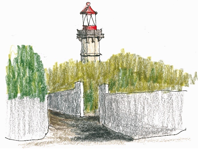
In Goderich, Ontario, I sketched the Goderich Lighthouse which is on a 130 foot bluff overlooking the harbor—so steep a person could fall to her death.

Goderich Lighthouse is the oldest on Lake Huron, dating from a pair of range lights put up in 1830. The current building was completed in 1846 built from dressed limestone blocks.
As we drove away from the lake the land became pancake flat with windmills everywhere—supplementing Canada’s largely hydro electric grid.
Kathi was suffering from lighthouse fatigue and exhaustion. She wanted a little more slack time. But with ‘a long way to go and a short time to get there,’ we settled for a Holiday Inn Express in Sarina, Ontario, at the very tip of Lake Huron. Dinner was shepherd’s pie at Paddy Flaherty’s.
DAY 8 A big sketching day as we headed for Taylor’s place in Detroit. In the rain I drew Sarina’s Point Edward Front Range Lighthouse. The only sighting I could manage had an edge view of the daymark. I had to fake the shadow. We’d left Lake Huron now and were on the St Clair River which empties into St Clair Lake.

The 1959 concrete Point Edward Front Range Lighthouse replaced the 1903 light.
In Mooretown just down the road, we found the Corunna Rear Range Lighthouse with an attractive diamond daymark on top.

At the turn of the century, range lights were constructed at Corunna, Ontario, to mark the shoals at the head of Stag Island in the St Clair River. When the Coast Guard replaced the Corunna Rear Range Lighthouse with a new structure in a better location, it was up for grabs. The Moore Museum decided the lighthouse would fit with their collection of old buildings. In 1982 the lighthouse was lifted by crane onto a flatbed trailer and transported to Mooretown.
As we drove on, we discovered another lighthouse of unknown name or origin— steel tower with a red top.

The Unknown Lighthouse.
When we reached Thames River Range Rear Lighthouse it was time for lunch—Vermont white cheddar and hard salami sandwiches with ginger ale served out of the trunk.

Named after its more famous counterpart in England, the Thames River is a major tributary giving its water to St Clair Lake. The Thames River Rear Range Lighthouse was first lit in 1837. Sometime after 1878 a brick extension was added as evidenced by the decorative ring which, of course, had been the top of the first tower. The lighthouse is no longer in service, but it’s a graceful testament to bygone days.
The last sketch of the day was Pelee Passage Lighthouse on LakeErie. Sketch and caption are included in the section Lake Erie.
We were in Detroit at Taylor’s a day early. Quick dinner so Taylor could play with his Detroit Party Marching Band on Belle Isle. Kathi and I walked up to the William Livingston Memorial Lighthouse toward the north end of the island. No sketch here because it’s not really a lighthouse and because I’d left my sketching stuff in the car. We walked back and enjoyed the band.
DAY 9 In the morning I drove to the nearest Audi dealership, which was in Farmington Hills, to check the tire pressure and adjust the map software. Farmington Hills a pleasant place with trees and shops and houses—contrast with Detroit. In the afternoon Kathi and I took off for Grosse Isl—large island in French and the largest in the Detroit River. The Grosse Isl North Channel Front Range Light was on a caisson accessible from someone’s private dock. As I trespassed on private manicured front lawns, a guy was nailing the lighthouse door shut. He didn’t approach me. I kept my head down.

The 1906 Grosse Isl North Channel Front Range Light was decommissioned in 1963, and in 1965 Grosse Ile Township purchased the tower from the US Department of the Interior. Restoration of the lighthouse started in 1984 with sheet piling and concrete to upgrade the foundation. The Grosse Ile Historical Society has added a new roof and several paint jobs. It’s been relighted with a characteristic of on for one second then off for one second, and listed on the Coast Guard’s Light List as a private aid to navigation.
Windmill Point Lighthouse is in Detroit’s Mariner Park with lots of people fishing. This miniatureish looking lighthouse was my last sketch on Lake Huron.

In 1838 the first lighthouse was built on Windmill Point. The Windmill Point Lighthouse which we see today was constructed in 1933.
That night we supped with Taylor at the Shewolf Pastificio on delicious Italian fare. After dinner I walked around Taylor’s neighborhood—flowers everywhere, Daises, Joe Pie, Black Eyed Susans, Hosta.
Kathi planned to stay with Taylor a couple more days before flying home, and I was off to Lake Erie in the morning.
Having Kathi with me was a great pleasure. She adapted to my compulsive sketching and I to her need for her own time and nonsketching activities. It was a wonderful trip—Kathi agreed.
As I sketched alone while Kathi was off exploring, I’d experienced the strange daydream-like illusion that I was traveling not with Kathi but with Sheryl. Six years on she still weighs heavily on my mind.

The Great Duck Island Lighthouse was not named for a great duck, it was named because it sits on the largest of the five Duck Islands which extend into Lake Huron from the south shore of Manitoulin Island. The 1877 lighthouse was replaced by the present white painted concrete octagon in 1918. William Boyle, great grandfather of Patrick Boyle who runs Boyle Marina in Little Current was keeper from 1919 to 1931.

Strawberry Island Lighthouse displayed a fixed white catoptric light for the first time in 1881. The light is now solar powered. The last keeper left in the 1960s. In 2006, it was declared a Recognized Federal Heritage Building. The lighthouse lies northeast of Manitoulin Island in Georgian Bay, Ontario.

Lonely Island Lighthouse is a story of grief. The second keeper of the 1870 lighthouse drowned when his boat capsized while moving supplies from Killarney. In 1882 the wooden steamer Asia foundered off the east side of the island with 100 people on board. Only two survived.
The island is located about 12 miles off the east end of Manitoulin Island in Georgian Bay, Ontario.

Copper deposits on the north shore of Lake Huron led to the establishment of Bruce Mines, named for James Bruce, Governor General of Canada at the time. The 1902 McKay Island Lighthouse was built in response to the increase in timber ship traffic. In 1975 the light was transferred to a steel frame tower, and the lighthouse went dark and became a rental.


Comments